 |
| Winter storm from StormPulse. Image taken a few minutes ago. Click on the image for a larger version. |

Sunday, December 26, 2010
Winter Blizzard
My fiance, my two cats, and I are currently up in New Hampshire visiting my parents and sister for Newtonmas. We have decided not to drive back down to Woods Hole today because of this:

Saturday, December 25, 2010
A Christmas Rock: Fossiliferous Coal
Merry Christmas & Happy Newtonmas, Everyone!
To celebrate, here are some beautiful pictures of coal taken from the interwebs. I'll take coal rocks like these in my stocking any Christmas!
To celebrate, here are some beautiful pictures of coal taken from the interwebs. I'll take coal rocks like these in my stocking any Christmas!
 |
| Fossil ferns in coal from Morocco. Image from Wikipedia Commons. |
Friday, December 24, 2010
A Famous Ocean Floor Map
Before I started a geology blog, I used to sporadically blog about geology over at Skepchick. These days, I blog here at Georneys about geology, and I blog over at Skepchick about other skeptical and scientific things, such as the silliness of having no 13th floor in buildings. Occasionally, I will re-post some of my old geology posts from Skepchick. I will also sometimes cross-post on both blogs. The post below originally appeared on Skepchick in 2007 here.
One of the most famous world maps is the 1977 World Ocean Floor Map (see above) created by Bruce Heezen and Marie Tharp, a pioneering female oceanographer and kick-ass female scientist. Prior to the publication of this map, scientists had very little idea of what the seafloor looked like on a global scale.
Although the concepts of mid-ocean ridges and plate tectonics seem innate to the work of oceanographers and geochemists today, these concepts are remarkably recent in their development. Plate tectonics was not fully accepted by the scientific community until the late 1960s and early 1970s, and this first great seafloor map was not published until the late 1970s. Mid-ocean ridges were not discovered until the work of Heezen and Tharp in the 1950s and 1960s.
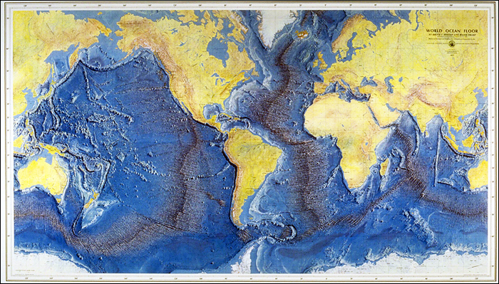 |
| The 1977 World Ocean Floor Map created by Bruce Heezen and Marie Tharp. Image taken from here. |
Although the concepts of mid-ocean ridges and plate tectonics seem innate to the work of oceanographers and geochemists today, these concepts are remarkably recent in their development. Plate tectonics was not fully accepted by the scientific community until the late 1960s and early 1970s, and this first great seafloor map was not published until the late 1970s. Mid-ocean ridges were not discovered until the work of Heezen and Tharp in the 1950s and 1960s.
Thursday, December 23, 2010
Geology Word of the Week: H is for Hotspot
 |
| Travertine forming at a hotspring, Yellowstone hotspot, Fall 2005. |
1. A place where you can obtain internet in order to write your geology blog.
2. A thermal anomaly within Earth's mantle, generally consisting of a hot, rising plume of mantle material that generates volcanism- or increased volcanism- on Earth's surface.
Friday, December 17, 2010
Audio Slideshow on My Thesis Research in Oman
 |
| Sitting on some travertine, Samail Ophiolite, Oman, January 2009. |
Click on the link below to watch the slideshow:
Oceanus Audio Slideshow
AGU Wrap-Up
 |
| San Francisco sunset, December 2010. Picture taken by my friend Kyle. |
Oh, well. Hopefully, we'll be able to rebook our connection in Salt Lake City and make it to Boston sometime late late late this evening. I have the best fiance ever- he flew in from South Africa (about 30 hours of traveling) on Saturday night and left with me for AGU Monday afternoon (another 13 hours or so of travel). He sat patiently through a full day of AGU on Tuesday and partial AGU days on Wednesday and Thursday. Fortunately, since he's also a geologist his company paid for him to attend AGU as well, so he was able to go off to some interesting sedimentary talks while I met up with colleagues and attended the CO2 sequestration talks which are related to my research. Now that we're looking at a very long trip home, my fiance is still being very sweet. He's been standing in line for about 30 minutes waiting to rebook our flight. I definitely have found myself a keeper.
Wednesday, December 15, 2010
Geology Word of the Week: G is for Gondwana
Note: I started the Geology Word of the Week at Skepchick, where I am one of several fabulous, skeptical women (and one deserving man) bloggers. For the first few weeks of the Geology Word of the Week, I am going to re-post my "Geology Words of the Week(ish)" from Skepchick. Before being distracted by graduate school and life, I made my way from A to G... I will re-post those letters here and then continue with the rest of the alphabet. In 26 weeks, I will have made my way through the alphabet!
This week we are at the letter G… I immediately thought of one of my favorite geology words: Gondwana!
def. Gondwana:
Gondwana is an ancient geological supercontinent that was comprised of modern-day Antarctica, South America, Africa, Australia, New Zealand, India, and Arabia. Gondwana first formed ~500 million years ago and later joined with the supercontinent Laurasia, that was comprised of modern-day North America, Europe, and Asia, to form a super-supercontinent named Pangea. Subsequently, Pangea began breaking up ~175 million years ago. The first stage of that separation was rifting of Laurasia from Gondwana. Eventually, all of the modern-day continents formed and gradually moved (over the past ~175 million years) into their present positions.
 |
| Gondwana Reconstruction. Image from Wikipedia Commons. |
def. Gondwana:
Gondwana is an ancient geological supercontinent that was comprised of modern-day Antarctica, South America, Africa, Australia, New Zealand, India, and Arabia. Gondwana first formed ~500 million years ago and later joined with the supercontinent Laurasia, that was comprised of modern-day North America, Europe, and Asia, to form a super-supercontinent named Pangea. Subsequently, Pangea began breaking up ~175 million years ago. The first stage of that separation was rifting of Laurasia from Gondwana. Eventually, all of the modern-day continents formed and gradually moved (over the past ~175 million years) into their present positions.
Subscribe to:
Posts (Atom)