The U.S. National Science Foundation (NSF) recently announced that they will fund only 6 months of scientific ocean drilling on the ship JOIDES Resolution in 2012. There is much need for scientific drilling, but NSF has been debating the expense of ocean drilling in the midst of budget cuts. There's a chance that NSF may choose not to fund any scientific ocean drilling in the near future (The Integrated Ocean Drilling Program ends in 2013), but for now drilling is cut down to just half the year. Since most drilling expeditions take ~2 months, this means only ~3 drilling expeditions will be funded next year.
As a marine geologist, the cut-back of ocean drilling makes me very sad. Ocean drilling provides much valuable scientific information, much of which cannot be obtain except with drilling.
Why is scientific ocean drilling important? My PhD advisor Susan Humphris explains why in this recent EOS article "The Need for Scientific Ocean Drilling."

Showing posts with label marine geology. Show all posts
Showing posts with label marine geology. Show all posts
Wednesday, June 8, 2011

Friday, December 24, 2010
A Famous Ocean Floor Map
Before I started a geology blog, I used to sporadically blog about geology over at Skepchick. These days, I blog here at Georneys about geology, and I blog over at Skepchick about other skeptical and scientific things, such as the silliness of having no 13th floor in buildings. Occasionally, I will re-post some of my old geology posts from Skepchick. I will also sometimes cross-post on both blogs. The post below originally appeared on Skepchick in 2007 here.
One of the most famous world maps is the 1977 World Ocean Floor Map (see above) created by Bruce Heezen and Marie Tharp, a pioneering female oceanographer and kick-ass female scientist. Prior to the publication of this map, scientists had very little idea of what the seafloor looked like on a global scale.
Although the concepts of mid-ocean ridges and plate tectonics seem innate to the work of oceanographers and geochemists today, these concepts are remarkably recent in their development. Plate tectonics was not fully accepted by the scientific community until the late 1960s and early 1970s, and this first great seafloor map was not published until the late 1970s. Mid-ocean ridges were not discovered until the work of Heezen and Tharp in the 1950s and 1960s.
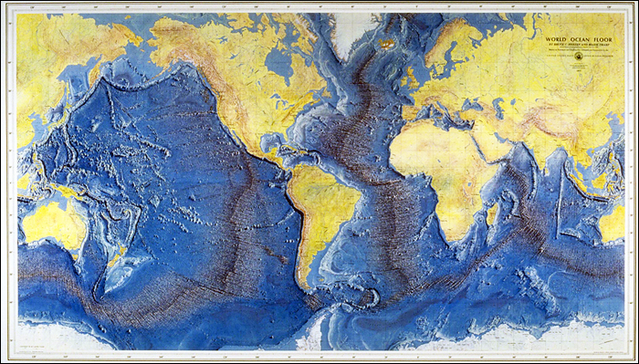 |
| The 1977 World Ocean Floor Map created by Bruce Heezen and Marie Tharp. Image taken from here. |
Although the concepts of mid-ocean ridges and plate tectonics seem innate to the work of oceanographers and geochemists today, these concepts are remarkably recent in their development. Plate tectonics was not fully accepted by the scientific community until the late 1960s and early 1970s, and this first great seafloor map was not published until the late 1970s. Mid-ocean ridges were not discovered until the work of Heezen and Tharp in the 1950s and 1960s.
Wednesday, November 24, 2010
Geology Word of the Week: D is for Dredge
Note: I started the Geology Word of the Week at Skepchick, where I am one of several fabulous, skeptical women (and one deserving man) bloggers. For the first few weeks of the Geology Word of the Week, I am going to re-post my "Geology Words of the Week(ish)" from Skepchick. Before being distracted by graduate school and life, I made my way from A to G... I will re-post those letters here and then continue with the rest of the alphabet. In 26 weeks, I will have made my way through the alphabet!
Over at Skepchick, I actually blogged about the geology word dip for the letter D. However, here at Georneys I cannot resist blogging about another geology D word: dredge!
def. dredge:
1. (verb, definition 1) Removing sediments or other material from one area and depositing them in another area, usually done in a lake or other body of water. For example, harbors and canals are often dredged to removed accumulated sediments so that the water remains deep enough for ships to pass safely.
2. (verb, definition 2) Searching for something lost or valuable by combing- so to speak- the bottom of a body of water. I think I most often hear this usage on shows such as "CSI" and "Bones." The detectives say something like, "We are going to dredge the lake/pond/entire ocean to look for the rest of the body."
3. (noun, marine geology) A tool used to collect geological samples from the seafloor. Dredges used to obtain rocks from the seafloor generally consist of a metal net attached to square metal shovel that scrapes rocks into the net. The dredge is attached to a ship with a cable and dragged along the seafloor. After dragging a dredge along the seafloor for a period of time or a certain distance, the dredge is hauled back up to the ship by the cable. When the dredge is successful, the metal net will be filled with rocks.
Over at Skepchick, I actually blogged about the geology word dip for the letter D. However, here at Georneys I cannot resist blogging about another geology D word: dredge!
 |
| A dredge, Indian Ocean, Summer 2007. |
1. (verb, definition 1) Removing sediments or other material from one area and depositing them in another area, usually done in a lake or other body of water. For example, harbors and canals are often dredged to removed accumulated sediments so that the water remains deep enough for ships to pass safely.
2. (verb, definition 2) Searching for something lost or valuable by combing- so to speak- the bottom of a body of water. I think I most often hear this usage on shows such as "CSI" and "Bones." The detectives say something like, "We are going to dredge the lake/pond/entire ocean to look for the rest of the body."
3. (noun, marine geology) A tool used to collect geological samples from the seafloor. Dredges used to obtain rocks from the seafloor generally consist of a metal net attached to square metal shovel that scrapes rocks into the net. The dredge is attached to a ship with a cable and dragged along the seafloor. After dragging a dredge along the seafloor for a period of time or a certain distance, the dredge is hauled back up to the ship by the cable. When the dredge is successful, the metal net will be filled with rocks.
Subscribe to:
Posts (Atom)